As a storyteller who loves to journey through history, few artifacts capture the imagination quite like a well-crafted map. They are not just geographical representations; they are time capsules, revealing the very pulse of a place at a specific moment. One such extraordinary document that offers a profound glimpse into the past is the Ratzer Map, officially titled “Plan of the City of New York in North America: surveyed in the years 1766 and 1767.” This detailed map of colonial New York City serves as an unparalleled window into urban life, military strategy, and the evolving landscape just before the American Revolution.
Created by British Army engineer and surveyor Bernard Ratzer, this map is renowned for its remarkable accuracy and intricate detail, especially considering the technology available at the time. I. N. Phelps Stokes, in his monumental work, Iconography of Manhattan Island, 1498-1909, rightly hailed it as “one of the most beautiful, important, and accurate early plans of New York.” Looking closely at this map of colonial New York City, whether in person at an archive or a high-resolution digital copy, immediately reveals why it holds such a revered place among historians and cartography enthusiasts. Its scale, design, and sheer volume of information are simply stunning.

Delving into Downtown: The Heart of Colonial New York
The focal point of the Ratzer map of colonial New York City is undoubtedly the city proper, situated strategically at the southern tip of Manhattan Island. This area was the bustling core of colonial life, a nexus of trade, governance, and military power. Fort George, the successor to the Dutch Fort Amsterdam, dominates the southern waterfront, a clear indicator of the British military presence and control over the harbor entrance.
Zooming in on this section of the map of colonial New York City, you discover a labyrinthine street network that feels surprisingly familiar even today. Many streets retain their original names, echoing through centuries: Wall Street, Pearl Street, Water Street, John Street, and Division Street are all clearly depicted. This persistence in nomenclature offers a tangible connection to the city’s colonial roots.
What to Eat in Fort Worth – A Culinary Deep Dive
Discover the Top Restaurants in Denver – A Culinary Journey
Discover Where to Visit in Las Vegas
Beyond the street grid, the map meticulously labels key buildings, providing a snapshot of the city’s infrastructure and social fabric. Churches were prominent landmarks, with 18 different congregations noted, including the Jewish Synagogue, reflecting the diverse religious landscape of the time. Other essential sites marked include City Hall, the prison and house of corrections, a theater, King’s College (the precursor to Columbia University), the Jewish cemetery, various markets, and military installations.
Examining these labeled buildings on the map of colonial New York City gives us insight into the daily life and public spaces that defined the colonial experience. Planning a visit to trace these historic steps? You might find a new york tourist guide book helpful in navigating the modern city while keeping its colonial past in mind.
Beyond the Wall: Estates and Unclaimed Lands
Moving northward from the dense urban cluster on the map of colonial New York City, the landscape transitions dramatically. Here, large landholdings belonging to prominent families dominate the scenery. The map clearly delineates the vast estates of figures whose names are still etched into the city’s geography, such as Bayard, Lispenard, Delancy on the west side, and the Stuyvesants to the east.
This patchwork of large tracts illustrates the agrarian nature of much of Manhattan above the city limits in the 1760s. Very little land remained truly “unclaimed” on the main island, save for areas like the extensive salt meadows of the Lower East Side and certain inlets along the East River. The division of land into these large estates significantly shaped the future development of the island, dictating the patterns of growth and urbanization that would follow in the next century.
The contrast between the tightly packed city and these sprawling estates on the map of colonial New York City offers a visual representation of the demographic and economic divides of the era. Many of these historical sites and areas relate closely to what is now considered among the famous things in new york.
A Glimpse Across the Water: Colonial Brooklyn
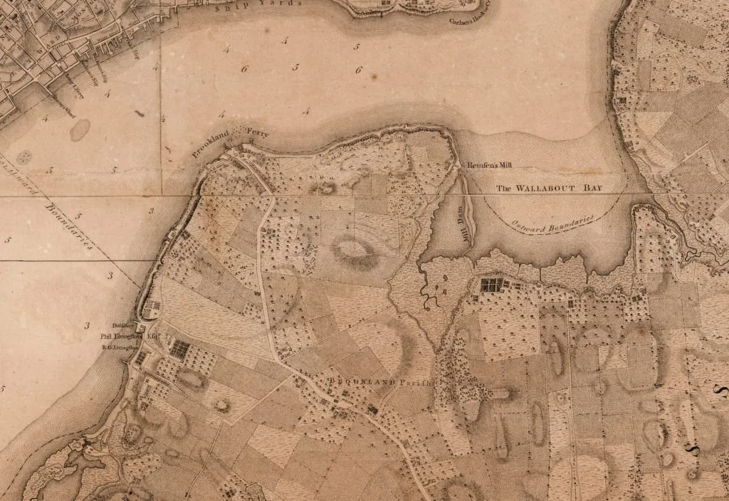
While the focus is “New York,” the Ratzer map of colonial New York City extends its detailed survey across the East River to depict a very different landscape: colonial Brooklyn on Long Island. In stark contrast to the bustling city, Brooklyn is shown as a predominantly rural expanse, dotted with a few small hamlets.

The map highlights key areas like Brookland Parish, clustered around its Dutch Church, and the Brookland Ferry area, which, according to historical accounts like Henry R. Stiles’ A History of the City of Brooklyn, contained only about 50 dwellings at the time. The rest of the area is divided into cultivated land and farms, connected by a nascent road network leading back to the ferry landing – the vital link for transporting goods to the markets in New York.
Studying the Brooklyn section of the map of colonial New York City vividly illustrates the vast natural environments that once dominated the landscape. The expansive salt meadows of Red Hook, Gowanus Creek, and Wallabout Bay are clearly visible. Comparing this rural, marshy coastline depicted on the 1760s map to the densely populated, industrialized, and now gentrified areas of modern Brooklyn highlights a dramatic transformation over the centuries. It underscores how human development has profoundly reshaped the natural world. This historical perspective can even enrich your appreciation of unique things to do in brooklyn today, understanding the deep history beneath the modern facade.
The Panoramic View: A City on the Rise
One of the most captivating features of the Ratzer map is the detailed panoramic illustration included below the main survey: the “Southwest View of the City of New York taken from Governor’s Island.” This isn’t just a decorative element; it’s a valuable visual record that complements the technical map of colonial New York City.
The view on the right side of the panel shows the Long Island shore, with the distinctive bluffs of Brooklyn Heights instantly recognizable. We see the small cluster of buildings near the ferry landings at the base of the heavily wooded ridge – a humble settlement compared to the city across the water.
The left and central portion, focusing on New York itself, presents a city facing the harbor, a nearly solid mass of buildings punctuated by church steeples. The harbor is teeming with ships, highlighting New York’s crucial role as a port city. Two plumes of smoke rise into the vast sky, perhaps indicating industry or domestic life.
This visual depiction on the map of colonial New York City offers a powerful sense of the city’s scale and activity at the time. While the specific buildings have changed, and the scale has multiplied exponentially, the image of a dense, urban environment facing a busy harbor is a vision that resonates with the modern perception of New York City – a testament to its enduring identity as a vibrant, human-centric landscape. Understanding its origins through this historical map helps explain what is nyc famous fors today.
The Map’s Legacy and Historical Context
The Ratzer map of colonial New York City gained even more significance with the onset of the American Revolution. A second state of the map, printed in 1776, is particularly notable. Copies from this printing were used by British military leaders during the New York and New Jersey Campaign, including Lieutenant General Hugh Percy, whose personal copy famously contained annotations showing American positions just before the Battle of Brooklyn – a crucial early engagement of the war. This connection to the Battle of Brooklyn, which occurred shortly after the map’s creation, imbues it with profound historical weight, moving it from a mere geographical record to a document tied directly to military strategy and conflict.
Studying the map of colonial New York City allows us to appreciate the strategic importance of New York Harbor and the surrounding waterways, which made the city such a critical military objective for both the British and American forces. The detailed depiction of topography, roads, and settlements would have been invaluable for planning troop movements, supply lines, and defensive positions.
Finding Your Own Connection
One of the most engaging ways to interact with the Ratzer map of colonial New York City is to try and locate where your own modern neighborhood stands. This exercise creates a personal story, bridging the gap between the 18th century and today. Seeing the salt meadows, forests, and farms that once occupied the ground now covered by skyscrapers and bustling streets offers a powerful sense of the scale of transformation.
While the original exhibit mentioned in the source text is long past, the Ratzer map remains a cornerstone of many historical collections, including the Brooklyn Historical Society (now the Center for Brooklyn History at the Brooklyn Public Library). High-quality reproductions and digital versions are also widely available, allowing enthusiasts worldwide to study its details. Engaging with this map of colonial New York City provides not just a history lesson, but a tangible connection to the people and landscape of a pivotal era in American history.
Conclusion: A Timeless Window
The Ratzer map of colonial New York City is far more than just an old chart. It’s a masterpiece of cartography and a vital historical document that unlocks countless stories about life in the mid-18th century. From the strategic military footprint at Fort George to the diverse religious sites, the sprawling rural estates to the undeveloped wetlands of Brooklyn, the map offers a comprehensive look at the landscape and urban fabric just as the winds of revolution began to stir.
For anyone interested in the history of New York City, the colonial era, or the power of historical maps, exploring the details of this extraordinary document is an incredibly rewarding experience. It allows us to walk the streets alongside colonial New Yorkers, understand the geographical challenges and advantages they faced, and appreciate the remarkable transformation of this iconic metropolis. The map of colonial New York City stands as a timeless window into the past, helping us understand the foundations upon which modern New York was built.
[

![Exploring the Map of Colonial New York City - Unlocking 18th-Century Secrets Detail showing Red Hood and Gowanus Creek, Plan of the City of New York in North America, surveyed in the years 1766 & 1767. [1770]. Brooklyn Historical Society Map Collection.](https://lifetodiscover.com/wp-content/uploads/2025/05/detail-showing-red-hood-and-gowanus-creek-plan-of-the-city-of-new-york-in-north-america-surveyed-in-the-years-1766-1767-1770-brooklyn-historical-society-map-collection.webp) Detail showing Red Hood and Gowanus Creek, Plan of the City of New York in North America, surveyed in the years 1766 & 1767. [1770]. Brooklyn Historical Society Map Collection.
Detail showing Red Hood and Gowanus Creek, Plan of the City of New York in North America, surveyed in the years 1766 & 1767. [1770]. Brooklyn Historical Society Map Collection.