Looking at a Vietnam Map World isn’t just about seeing lines and colors; it’s the first step into uncovering a land rich in history, vibrant culture, and breathtaking landscapes. As a travel enthusiast deeply connected to the stories places tell, I see the geography depicted on any Vietnam Map World not just as locations, but as the stage for centuries of human drama, culinary evolution, and unique experiences waiting to be discovered. This map is a window into a country defined by its dramatic coastline, fertile deltas, and rugged mountains, each feature shaping the identity of its people and the experiences it offers.
Understanding Vietnam’s Diverse Regions Through the Vietnam Map World
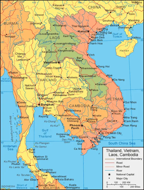
Vietnam’s striking S-shape on the map tells a story of incredible geographical diversity, stretching over 1,600 kilometers (nearly 1,000 miles) from north to south. Bordered by China to the north, and Laos and Cambodia to the west, its extensive eastern coastline meets the South China Sea and the Gulf of Tonkin. This long, narrow form creates distinct northern, central, and southern regions, each with unique climates, landscapes, and cultural characteristics. The map highlights key geographical features that influence everything from agriculture to architecture and local customs.
 Vietnam political map
The north, home to the capital Hanoi, is characterized by mountains and highlands, including the towering Fan Si Pan. This topography has historically influenced its more reserved culture and heartier cuisine, adapted to cooler climates. Central Vietnam, with cities like Hue and Da Nang, features a narrower strip of land, a dramatic coastline, and historical sites reflecting imperial heritage. The south, centered around bustling Ho Chi Minh City and the vast Mekong Delta, is flatter, more tropical, and known for its vibrant, entrepreneurial spirit and abundant agricultural produce. Exploring a Vietnam Map World helps visualize these regional differences.
How Geography Shapes Vietnamese Cuisine: A Culinary Map
The physical geography shown on a Vietnam Map World has a profound impact on the country’s diverse and celebrated cuisine. Each region boasts its own specialties, dictated by available ingredients and historical influences. In the mountainous north, dishes often feature freshwater fish, pork, and the iconic pho, a hearty noodle soup perfect for cooler weather. The map’s depiction of rivers and highlands directly correlates to these culinary foundations.
Central Vietnam’s proximity to the coast means seafood is prominent, while the historical imperial capital of Hue in this region developed sophisticated, visually stunning dishes. Southern cuisine, influenced by the tropical climate and the fertile Mekong Delta (easily spotted on the map by its network of rivers and waterways), is typically sweeter, utilizing an abundance of fresh herbs, tropical fruits, and coconut milk. The map isn’t just about political borders; it’s a guide to the ingredients that fill the country’s vibrant markets and street food stalls, offering a true taste of place.
From Coastline to Highlands: Travel Experiences on the Vietnam Map World
A Vietnam Map World serves as an invaluable tool for planning incredible travel experiences. The extensive coastline invites exploration of world-renowned beaches like those near Da Nang or the islands in the South China Sea. The rugged northern mountains are a trekker’s paradise, offering challenging hikes and opportunities to visit ethnic minority villages. Iconic locations like Ha Long Bay, with its dramatic limestone karsts, are directly linked to the coastal geography visible on the map.
Travelers can trace the course of the mighty Mekong River in the south, navigating its intricate delta system by boat, witnessing vibrant floating markets, and experiencing rural life. Major cities like Hanoi and Ho Chi Minh City (Saigon), clearly marked on the map, offer a blend of historical sites, modern energy, and incredible urban exploration, reflecting centuries of development influenced by their strategic locations. Understanding the geography on the Vietnam Map World helps unlock the potential for adventure and cultural immersion.
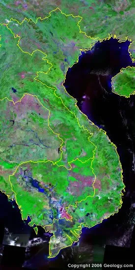
 Vietnam satellite photo
The map also hints at some of the challenges the country faces, such as the environmental issues mentioned in the original source, including deforestation and water pollution, often more pronounced in densely populated or heavily exploited areas. Natural hazards like typhoons are also tied to Vietnam’s location along the South China Sea. Being aware of these geographical realities enhances a traveler’s understanding and encourages responsible tourism.
More Than Just Boundaries: The Living Map
Ultimately, looking at a Vietnam Map World is more than just observing political boundaries or physical features. It’s about appreciating the canvas upon which a resilient people have built a rich history, developed unique cultural expressions, and cultivated a globally recognized culinary tradition. The mountains, rivers, and coastline aren’t just lines; they are integral parts of Vietnam’s story, influencing everything from ancient battles to modern-day farming techniques.
Discover the Best – Where to Go on Vacation in Florida
Your Ultimate Guide – what to eat in destin florida
Discover Fun Things to Do in LA Today
Whether you’re interested in tracing historical routes, discovering regional food variations, embarking on outdoor adventures, or simply understanding the layout of its dynamic cities, the map is your starting point. It provides context for the experiences that await, connecting the abstract representation of land to the tangible realities of life, culture, and travel across this fascinating country. Use the Vietnam Map World not just to find your way, but to understand the soul of Vietnam.
Frequently Asked Questions About the Vietnam Map World
What are the major geographical regions of Vietnam shown on a map?
A Vietnam Map World typically shows three main geographical regions: the North (characterized by mountains and deltas), the Central (a narrow coastal strip with highlands), and the South (dominated by the flat, fertile Mekong Delta). These regions have distinct climates, landscapes, and cultural traits influenced by their geography.
How does Vietnam’s geography influence its culture and cuisine?
Vietnam’s diverse geography directly shapes its culture and cuisine. The varied climates and landscapes across the North, Central, and South provide different ingredients, leading to regional culinary variations. Geographical divisions also historically contributed to regional identities and cultural differences that persist today.
What key cities should I look for on a Vietnam Map World?
Important cities to locate on a Vietnam Map World include the capital Hanoi in the North, the historical imperial city of Hue and coastal Da Nang in the Central region, and the bustling Ho Chi Minh City (formerly Saigon) in the South, which is the largest city. These cities represent major cultural, historical, and economic centers.
